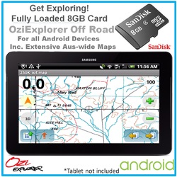


Android Detailed Australia-wide Topographic Digital Maps & OziExplorer on 8GB Card
Item Number: SF-36
Sold Out
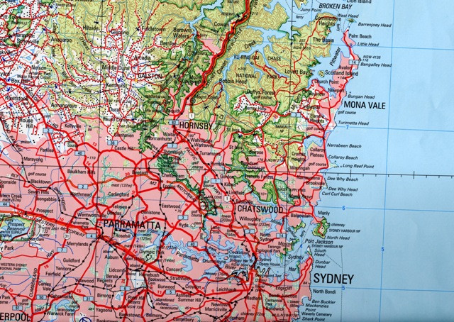
Australia-wide Topographic Toppo Digital Maps are detailed digital maps covering Australia's beautiful surface. They cover the whole of Australia at 1:250 000 scale with more referenced land features than most other maps.
Have Questions? Contact Us Here


OxiExplorer Demo Video
Turn your Android Phone or Tablet into an Off Road Navigator!
Includes detailed off road maps and android APK Ozi Explorer Off Road Software.
Please note that OZIEXPLORER is a licenced product. The Card contains APK and detailed off-road maps. You can purchase the licence separately through our website. Search for the Code "OZILIC-AND"
The supplied SD Card will container Australia-wide maps and will work on any android device with inbuilt GPS, no matter what brand you have.
Includes Ozi Explorer For Android as well as detailed Australia-Wide Digital Maps, pre-converted for Ozi Explorer.
What you get:
- OziExplorer Android
- Full Austalian-Wide Topographic Maps
- 8GB Micro SD card with Adaptor
- Installation Instructions
If you love the outdoors and driving on unsealed road and looking for a real time moving map with tracking on your Android Tablet or Phone then look no further. This is the perfect addition to your android tablet or phone.
Ozi Explorer features:
- Speed
- Altitude
- Compass
- Mark waypoints
- Breadcrumb trail
- Log & save tracks
- Many map zoom levels
- More/Less detailed maps
- Automatic loading of next map
Australia-wide Topographic Toppo Digital Maps are detailed digital maps covering Australia's beautiful surface. They cover the whole of Australia at 1:250 000 scale with more referenced land features than most other maps. These maps usually cost $99 on their own.
- Roads: Major road to public or private track with minimum or no construction
- Hydography: Watercourse, canals, perennial lake, bore, well, windpump, waterhole, spring, swamp
- Cultural features: Pipelines, tanks, homesteads, ruins, landmarks, fence, quarry, mine
- Boundaries: State & territory borders, reserves and prohibited areas
- Railways: Tracks, stations, sidings and abandoned lines
- Vegetation Forest, scrubland, rain forest, plantation, orchard
- Aircraft facilities: Airport, landing strip, helipad
- Offshore & Coastal features: Boat ramp, lighthouse, reef, shaol, wreck, costal flat, mangrove
- Relief: Elevation, sand dunes, cliffs, sand ridges, pinnacle and contour lines with values.
Areas covered:
Cape York, Cape York Tip, Central Australia, Central QLD inset4 Bundaberg, Central QLD inset5 HerveyBay, Central QLD inset2 Gladstone, Central Queensland, Central QLD inset3 Gemfields, Central QLD inset1 Rockhampton, East Gippsland, Flinders Ranges NP, Flinders Ranges Vulkathunha - Gammon Ranges NP, Flinders Ranges Mt Remarkable NP, Flinders Ranges Mainmap, Fraser Island, Fraser Island - MidFraser, Fraser Island - Rainbow Beach, Fraser Island - Central Station, Boonoo Boonoo NP, Girraween and Bald Rock NPs, Sundown NP, Goldfields Esperance, Stokes NP, Goldfields Region, Cape Arid NP, Stirling Ranges NP, Cape Le Grand NP, Fitzgerald River NP, GDT South Central, GDT North West, GDT North East, GDT North Central, GDT South West, GDT South East, High Country Victoria East, High Country Victoria West, The Kimberley, Lakefield NP - Hann River, Lakefield NP, Lamington NP, Melbourne to Adelaide, Great Ocean Road, Mid North Coast and New England, Mount Augustus NP, Mid West WA, Francois Peron NP, Kalbarri NP, Cape Range NP, Kennedy Range NP, North East NSW, North QLD, North QLD Whitsunday Coast, Mungo NP, Outback NSW, Kinchega NP, Mutawintji NP, Sturt NP, Outback QLD Diamantina NP, Outback QLD Currawinya NP, Outback QLD, Outback QLD CarnarvonGorge, Outback QLD Bladensburg NP, Outback QLD SalvatorRosa KaKaMundi, Outback QLD Idalia NP, Outback QLD MtMoffat, Rudall River - Karlamilyi NP, Millstream Chichester NP, Karijini NP, Pilbara and Coral Coast, Purnululu NP, Purnululu NP Inset, The Red Centre, Simpson Desert 1_1m, Simpson Desert 500k, Snowy Kosciuszko, South East NSW, South East Queensland, Margaret River Wine Region, South West Corner WA, Albany Coast, South West Western Australia, Lane Poole Reserve, SW Corner, Avon Valley NP, Stirling Range NP, Nambung NP, DEntrecasteaux NP, Nhulunbuy, Keep River NP, Boodjamulla NP, Gregory NP, Darwin Region, Top End and Gulf, Litchfield NP, Kakadu NP, Tropical North Queensland
About OziExplorer
OziExplorer (OE) is a program written by australian Des Newman and his wife Lorraine. It closes the gap between a scanned map and the digital output of your GPS. What it basically does is putting the GPS output in a graphical form so you can look at a map (or picture) to see exactly where you are. It displays your present position, the direction you are heading and the way you came from. You can also add comments and events without altering the map. Pictures can also be included.
Des initially made this for his own 4x4 activities but it proved very useful for others too. Here his own comments: "The software was developed to allow me to set up my 4 wheel drive trips. Before the trip I scan in the relevant map if I have not already done so. I then sit down and work out where I am going, and using OziExplorer, position waypoints on all the road and track intersections and towns etc. Add in Map Features and Map Comments where appropriate. Use events to mark the position of the roads and tracks. I save all these to files as necessary. I add waypoints and events to more than cover the region I expect to visit to allow for change of plans. When I am happy with the map I then send the waypoints and events to the GPS and print the map and waypoint list."
| SKU | SF-36 |
| Barcode # | 9357423019166 |
| Brand | OziExplorer |
| Shipping Weight | 0.1000kg |
| Shipping Width | 0.100m |
| Shipping Height | 0.030m |
| Shipping Length | 0.030m |
| Assembled Width | 0.100m |
Be The First To Review This Product!
Help other Masten Enterprises Pty Ltd users shop smarter by writing reviews for products you have purchased.